 EMODnet Product Catalogue
The Crown Estate
Type of resources
Available actions
Topics
Keywords
Contact for the resource
Provided by
Years
Formats
Representation types
-
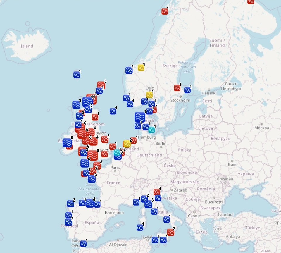
The dataset on ocean energy in the European seas was created in 2014 by AZTI for the European Marine Observation and Data Network (EMODnet). It is the result of the aggregation and harmonization of datasets provided by several sources from all across the European countries. It is updated every year, and is available for viewing and download on EMODnet web portal (Human Activities, https://emodnet.ec.europa.eu/en/human-activities). The dataset contains points representing Ocean Energy project sites in the following countries: Belgium, Denmark, Finland, France, Ireland, Italy, Norway, Portugal, Russia, Spain, Sweden, The Netherlands and United Kingdom. Where available, each point has the following attributes: site code (ID_1), project code (ID), name, location, country, sea basin, sea, distance to coast (metres), resource type (wave, tidal, salinity gradient, wave/wind), starting year, ending year, lease status, technology (Based on www.aquaret.com/), device, device scale (Full scale, prototype, etc.), project scale (Commercial, Demonstrator Array, etc.), project status (operational, completed, etc.), project capacity (KW), promoter, position info (it indicates if the attribute value is original from the source or has been estimated or calcultated the polygon centroid) and the studies conducted for the environmental assessment (EIA). In 2016, a feature on areas for ocean energy test sites was included. It contains polygons representing Ocean Energy test sites in the following countries: Denmark, France, Ireland, Norway, Portugal, Spain, Sweden, The Netherlands and United Kingdom. Where available, each polygon has the following attributes: test site code, name, location, country, sea basin, sea, distance to coast (metres), resource type (wave, tidal), starting year, ending year, lease status, site status, capacity (kW), depth (metres), area (square km), grid connection, number of berths, developer, position info (it indicates if the attribute value is original from the source or has been estimated) and the studies conducted for the Environmental Assessment (EIA). In 2023, new data has been included and existing data has been updated.
-
GEMS Survey Ltd. (GEMS) were contracted by Forewind Limited to undertake a bathymetric and geophysical survey of the Tranche A development area and two met mast locations (which were later revised) within the Dogger Bank Zone, in addition to a cable reconnaissance from Tranche A to the Yorkshire coastline. This survey was carried out between 8 July 2010 and 26 December 2010. The primary objectives of the survey were to produce sufficiently high resolution bathymetric and geophysical data and interpretations to allow regional interpretation for planning and modelling purposes; for met mast design to commence and to provide high quality data to inform further benthic and environmental surveys. GEMS supplied interpreted datasets compatible with ESRI ArcGIS software. The GIS data included bathymetry, sidescan sonar mosaics, seabed features, sediments and obstructions.
-
Gardline Geosurvey Limited was contracted by Forewind Limited to survey the Dogger Bank Wind Farm Area between 04-Apr-2013 and 02-Aug-2013; work was undertaken on the inter project cable route corridors, the Tranche C zonal survey and the Met Mast West. The aim of the surveys was to carry out a geophysical investigation that would broadly assess the entire developable area of the zone and route. Seabed information was required in order to inform the site selection process and enable preliminary foundation design to be undertaken. The geological data acquisition programme was carried out on M.V. Sea Surveyor, which sailed from Hull and returned to Blyth upon completion of survey operations and M.V. Vigilant which sailed from Great Yarmouth and to where they returned upon completion of survey operations. This dataset is MBES (MultiBeamEchoSounder) data obtained using a Simrad EM710. Processed using Caris HIPS and SIPS 7.1 to produce a digital terrain model (dtm) of the bathymetric surface. Available in the following format: 1) xyz - space delimited text file of gridded bathymetry. Data stored as: Column One: Easting Column Two: Northing Column Three: Water Depth 2) Ungridded Soundings - space delimited text file of the 'point cloud' of MBES soundings. Data stored as: Column One: Easting Column Two: Northing Column Three: Water Depth 3) Arc ASCII grid - raster text file of gridded bathymetry.
-
Lewis Wave Power Ltd. (LWP) (a wholly owned subsidiary of Aquamarine Power Ltd.) was seeking to develop a wave energy demonstration array off the west coast of the Isle of Lewis. As a first stage of the Environmental Impact Assessment (EIA) for the project, LWP commissioned Royal Haskoning Ltd. to produce an Environmental Scoping Report (Lewis Wave Power Ltd., 2011) to facilitate the identification and assessment of the potential environmental impacts associated with the project. The survey reported on here formed this field-based benthic component. Its purpose was to provide site-specific benthic data to inform an assessment of impact of the proposed development. The key objectives were to: Determine the distribution and abundance of marine habitats and communities within the study areas; Determine the substrate type at all locations sampled and Identify habitats or species of conservation importance.
-
Fugro GeoConsulting Limited (Fugro) was requested by Centrica Energy Renewable Investments Limited (CERI) to perform a geotechnical investigation at the South-East Development Area of the proposed Irish Sea Wind Farm to provide sufficient data to enable the zone-wide characterisation of the soil and rock conditions for combination with the regional geophysical data to inform the technical and commercial planning process. The work was performed from the MV Normand Mermaid from 4 April 2012 to 29 September 2012, in accordance with the instructions received from CERI. Two drilling methods were mobilised for the work: the standard downhole American Petroleum Institute (API) drilling spread and a Geobor S piggyback coring spread. The fieldwork consisted of 43 boreholes: 19 boreholes utilising the API drilling spread to characterise engineering soil and prove depth to bedrock, and 24 boreholes using the API drilling spread with follow-on Geobor S boreholes to characterise engineering soil and bedrock to a target depth of 55 m. Downhole geophysical wireline logging was performed at each of the follow-on Geobor-S boreholes in order to enhance characterisation of the site. The datasets included within this package are 1.AGS data (.ags) 2.Wireline Digital Data (.las, .xls) 3. Images(.pdf, jpg) These datasets relate to the Centrica report document No: SE-D-EN-127-0117-501003-005.
-
The Crown Estate manages the UK seabed out to the 12 nautical mile territorial sea limit and, under the 2008 Energy Act, hold the rights for gas storage within the Exclusive Economic Zone Order 2013, which extends out onto the Continental Shelf. This Order incorporated the Gas Importation and Storage Zone Order 2009, which was created by the 2008 Energy Act. Offshore natural gas storage has been taking place within UK waters, in the Rough field, since 1983. Developers of offshore projects need a storage licence (from BEIS) and a storage lease (from the Crown Estate), as set out in the 2008 Energy Act, which also explains which type of gas importation and storage projects fit into this description. Effectively the regulatory and proprietary roles are separated. This dataset shows gas storage leases given by The Crown Estate. At this stage there are three leases, Rough, Gateway and Larne Lough. Rough acts as a storage facility for gas shippers and suppliers, allowing them to feed gas into Transco's National Transmission System when demand is at its peak, or withdraw and re-inject it into the reservoir when demand is low. Any company with a UK gas shipper licence can apply to purchase storage capacity at Rough. Gateway and Larne Lough are salt caverns. This data has been checked with the lease areas held by DECC to ensure they match. The dataset also includes pipeline information. These TCE Agreements pipelines are related to the Natural Gas Storage sector in the United Kingdom waters. Attribute information includes name, tenant and pipeline type. The data source is the individual owner company of the infrastructure.
-
At the request of Centrica Energy Renewable Investments Limited (CERIL), Fugro Geoconsulting Limited acted as the main contractor for a geotechnical site investigation at the Irish Sea Round 3 Wind Farm (Zone 9) site. The fieldwork was performed using the Fugro Saltire from 05 March to 24 March 2011. A total of nine boreholes were performed at the Irish Sea Round 3 Wind Farm (Zone 9) site. Four locations were investigated comprising a continuous in-situ testing and sampling program. The purpose of the investigation was to provide soils information and to assess the ground conditions. This data will assist in design of met masts for the proposed wind farm. This dataset includes borehole geotechnical log information and the cone penetration test (CPT) data for all of the CPT sites during the geotechnical survey together with supporting documentation. Video data was also collected but is not included in this dataset.
-
Partrac Ltd. were contracted by SSE Renewables to deploy three Waverider wave buoys and two ADCP frames at the proposed Islay Offshore Wind Farm site. The objective of the study was to provide wave data that will informthe physical processes modelling and engineering design. The Waverider buoys were deployed on 12th February 2012 until the 14th August 2012, with the ADCP frames being deployed in July 2012. Deliverables were in the format of reports and excel spreadsheets containing raw data. This dataset package contains the wave rider buoy reports, including raw data, QC'd data, failed data, flagged data and statistics.
-
GEMS Survey Ltd. (GEMS) was awarded a contract by Channel Energy Limited to undertake metocean data collection in the Bristol Channel as part of the Atlantic Array wind farm development project. The scope of work includes the deployment of two acoustic wave and current (AWAC) units and one Directional Waverider Buoy. Ancillary work includes water and sediment sampling and water profiling. Following non-recovery of AWAC devices, TRIAXYS Directional Wave buoys were utilised for the rest of the survey. This series contains both reports and datasets associated with the Metocean Assessment.
-
This dataset shows carbon capture and storage agreements given by The Crown Estate. At this stage there is one Agreement for Lease for a site called Goldeneye, along with an existing pipeline agreement. The proposed CO2 and storage reservoir area is owned by Shell and is planned to form part of the carbon capture and storage project with the SSE Peterhead power station. Carbon from the gas-fired power plant in Peterhead will be pumped to Shell's depleted Goldeneye gas field, located 65 miles off the coast of north east Scotland. The proposed SSE Peterhead project aims to design and develop a full chain, post-combustion CCS facility which will be capable of capturing the CO2 from one 385 MW combined cycle gas turbine unit. The first injection is planned for 2016. The Don Valley Power Project (formally known as Hatfield) seeks to demonstrate Carbon, Capture and Storage on a new, 900MW integrated gas-fuelled combined cycle (IGCC) power station in the Humber area. The emissions will be captured at the power station and will be transported away to the storage area. In October 2015, the CCS site (AfL) which is part of the White Rose project changed its name from Aquifer 5/42 to Endurance.